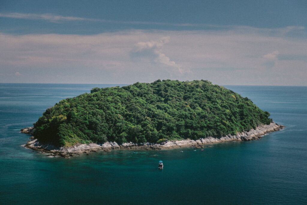
Charity Island – The Little Island With Many Histories
8 min read
Charity island is a lovely tree-filled island on Michigan’s Saginaw Bay. Saginaw Bay’s southern shore is ten miles from the Big & Little Charity Islands. This tiny island was significant in Michigan’s history. The island is empty, save for the seasonal residents who work at the B&B at the lighthouse keepers’ home. The U.S. Fish and Wildlife Services rates these islands among the less accessible and remote islands in the Michigan Island National Wildlife Sanctuary. Few people visit the island because of the shallow, dangerously choppy waters that surround it.
Charity Island Dominates Saginaw Bay
Big Charity Island is one of the bigger islands on the U.S. side of Lake Huron. It commands a commanding presence at the mouth of Saginaw Bay with its 250 acres. It contains an 11-acre spring-fed pond that is encircle by reeds. The U.S. Fish and Wildlife Service has designated both islands as off-limits to camping and hunting because they play an essential role in the area as a rookery for nesting Bald Eagles and other species.
Native American Island Chain History
According to local legend, the island has long served as a resting place for travelers across Saginaw Bay and a source for the “chert” stone, which is use to make stone tools. Big Charity Island was first referred to as Shawangunk on French maps of the region in the late 1600s. In the Lenape language of the eastern U.S. tribe, Shawangunk is translated as “in the smokey air.” The little island to the south was given the name “Traverse Island” by the French.
The LaSalle Voyages
On his way to Mackinac in the Griffin in August 1679, the French explorer de La Salle is said to have stopped at the island. Some historians, however, contest this assertion because it was stated that the Griffin traveled 30 miles across Saginaw Bay at night.
“The same day, the vessel scudded before a fresh breeze along the lake’s eastern shore, headed north by east until the evening when the wind changed to the southwest, and being very strong, they bore toward the northwest. On the ‘morrow M. de La Salle found himself in sight of land having crossed during the night a great bay named Sakeinam, which extends southward more than thirty leagues.”
Lewis Cass and Henry Schoolcraft’s Investigation
To survey the area and search for the Mississippi River’s source, Michigan’s territorial governor Lewis Cass was permit by American Secretary of War John C. Calhoun to lead a group of scientists, Canadian voyageurs, and Native Americans into the wilderness of the upper Great Lakes in 1820.
Henry Schoolcraft was one of the 40 explorers that Cass listed. Schoolcraft, a renowned mineralogist and geologist, were vital to the expedition’s success. They traveled across Saginaw Bay in a manner that is consistent with the widely-held theory that the route of Oak Point, Charity Island, and AuSable was a well-traveled Indian transit route that included a stop at the island as a safety precaution against the swiftly moving storms that are common in the bay.
The following entry in his journal:
“In crossing the bay, we landed a few moments upon Shawangunk island, which is found to be based upon compact limestone and contains embedded masses of Chalcedony and calcareous spar. During the short period we remained, I also picked up a lump of the argillaceous oxide of iron and some detached fragments of a coarse striped jasper. These discoveries created a strong desire to conduct a geological survey of the island. Still, we were prevented from attempting it by the necessity of expeditious progress across the bay while the weather favored.”
The expedition continues to the mouth of the Au Sable river, then to Michilimackinac, and presses on to Sault de Ste. Marie and Fond du Lac and into Wisconsin.
The Lumbering Era In Michigan And Charity Island

Early in Michigan’s lumbering history, the region around Saginaw Bay was exploited for its timber (1830-1910). On almost every river outlet that flowed into Lake Huron or Saginaw Bay, sawmills were constructed. Mills were built in Bay City, Saginaw, Sebewaing, Caseville, Port Crescent, New River, and Port Hope. Rivers could easily transport logs to sawmills close to the lakeside ports. In addition, the limestone reefs and shoals near the tip of the thumb and around Charity Island were challenging for ships entering the narrow harbor.
Navigational problems plagued the Great Lakes. As part of a brand-new regional lighthouse district, Lieutenant James T. Homans was tasked with evaluating the waterways west of Detroit in 1838. Horman was responsible for compiling reports on each state and formulating suggestions for additional lighthouses. He suggested, among other things, building a lighthouse at the mouth of Saginaw Bay. (5)
Construction of the Charity Island Lighthouse
The $5000 lighthouse project on Traverse or Charity Island in Saginaw Bay was authorized by Congress. (And for the same price, the Port Austin Lighthouse) (2) The island’s construction started in 1856 lasted through 1857. Using brick that was transported from Milwaukee on the steamer Search, a 39-foot brick structure was built. The editor of the Bay City Express was sailing by the island on the ship as the tower was being constructed. He criticized the government for such a useless expense in a newspaper article on Jun 6, noting that the island itself was a well-known supplier of high-quality building stone.
Captain George Meade was given the order to start surveying the Upper Great Lakes, including Saginaw Bay, while the lighthouse was being built. No precise maps depicted the actual distances and depths of the region, and the bay was crucial to the nascent state’s logging business. As a result, wrecks and groundings became all too prevalent. Meade began surveying Lake Huron at the long peninsula of Sand Point, where he established the baseline. Using this location as his base, he built triangulation towers at strategic locations along the north and south shore, as well as a recently made lighthouse on Charity Island in the middle of the harbor.
As the light’s first keeper, Colin Graham assumed control of it in May. Soon after the tower and light were finished, regular operations started. The morning offered a visual range of 13 nautical miles. Therefore, 13 nautical miles were determined to be suitable for both keeping boats off the island and navigating from one light to the next when this range was created as the government was building a set of lights up and down the coast.
The Oconto Wreck of 1885
The passenger ship Oconto departed from Oscoda on the afternoon of Dec 4, 1885, headed towards Alpena. However, a blinding snowstorm and gale-force winds met the boat in the harbor. Captain McGregor decided to turn around and seek refuge in the adjacent Tawas Bay. The vessel ran aground in the shallows surrounding Charity Island because its trajectory was too far east in the gale. The lighthouse gave the captain and his men the impression that they were close to Tawas. After releasing the ship, they turned back but ran aground again, stopping completely.
The passengers and crew survived the gale until the next day on board the Oconto. The ship was trapped but not taking on water. The evening was terrible. They were transporting livestock, which escape and got lost in the ship. They could tell the boat was approximately a mile away from Charity in the early morning light. The lighthouse keeper McDonald and his helper William Pierce soon arrived on land after the captain gave the all-clear with a whistle. They started the rescue effort by launching a lifeboat.
A rowboat was used to transport the 23 passengers and some crew members to shore. Two ladies and a child who went to the lighthouse while the men sought refuge in the fishing cottages on the island. Over the following week, the crew and the 47 disaster survivors dispersed.
While every traveler made it through the adventure alive, the ship’s chef, Charles Brown, reportedly passed away from shock and was buried on Charity Island.
They salvaged the Oconto in the spring. However, the Oconto sank at Fisher’s Landing, not far from the St. Lawrence river.
Fishing industry role of Charity Island
In 1926, the government sold Charity Island to the Gillingham Fish Company, keeping just the reserve for the lighthouse. The 1886-founded Gillingham Fish Company bought the island in the 1920s and 1930s at the height of their fish output. Refrigerated railroad carriages transported tons of perch, walleye, herring, whitefish, and carp from Bay Port to New York and Chicago. To buy Little Charity Island from the indebted Beutel Fisheries Company, Bay Port Fish Company sold $30,000 worth of stock in November 1915.
End of An Era – Automation of the LIghthouse
The first Great Lakes lighthouse to be fully automated was the Charity Island Lighthouse in Saginaw Bay in 1916. Between 1939 and 1942, the Charity Island Lighthouse was abandon in favor of a newer light at Gravelly Shoals, situated closer to the shipping lanes. The keeper’s home and the tower were left to the elements.
The Gillingham Fish Company sold big Charity island to Saginaw business people in 1963, so they could develop it as an island getaway. A landing strip, bridle pathways, and bicycle trails were planned. For the lighthouse reservation at the northeastern tip of the island, the General Services Administration got a top offer of $15,500.
Charity Island Development
Charity Island purchased by Standish real estate agent Robert Wiltse and investors in 1993 for development. Twenty-four opulent villas are what they have in mind for the island. It took sixty thousand pounds of dynamite to carve out a small harbor for the project’s initial phase. It took 16 weeks to finish the marina with a channel to link it to the lake.
The U.S. Fish and Wildlife Service purchased most of the island from Witse in 1997. As a new addition to the Michigan Islands NWS after abandoned development plans. The nonprofit Nature Conservancy purchased the lighthouse from the government and a few more acres from Wiltse.
Charity Island Sightseeing Cruises and Island Lodging
We built a new house on the site in 2003, hosting weekend visitors for lighthouse sightseeing and dinner cruises. Guests can embark on the island from Caseville with Explorer Charter Cruises or Au Gres with Charity Island Transport. A new lodge was also built for those who want to say on the island. It sleeps four, and there is a three-night minimum stay.
Final Thoughts About Charity Island
Charity island has been a small part of Native American Michigan history. Today it stands primarily isolated in Saginaw Bay’s busy sports fishing area. Yet, while visitors are few, it remains a natural part of the beauty of Michigan.
Sources
Relation of the Discoveries and Voyages of Cavelier de La Salle from 1679 to 1681: The Official Narrative www.americanjourneys.org/aj-122/ Page 35.
(2) THIRTY-FOURTH CONGRESS. SESS. I. C. 160. 1856 p 100.
(3) Bay City Express, in its issue of Jun 6, 1857
(4) A Sesquicentennial History of the Corps of Topographical Engineers 1838-1863
(5) Great Lakes Navigation and Navigational Aids Historical Context Study By Theodore J. Karamanski 2017, National Park Service
(6) New York Times Dec 12, 1885
(7) GLMS 19 – Bay Port Fish Company, Bowling Green State University


